
Alluvial Soil
Alluvial Soil
- Alluvial soil is the most extensive, widespread, and agriculturally significant soil type in India. Covering approximately 15 lakh square kilometres (about 43% to 45.6% of the country’s total land area), it forms the backbone of India’s agricultural wealth and sustains a major portion of the population.
1. Formation and Composition
- Origin: Formed primarily by the depositional action of sediments transported by rivers, winds, glaciers, and sea waves.
- Nutrients: They are generally rich in potash, lime, and humus, but frequently deficient in nitrogen and phosphorus.
2. Classification:
Alluvial soils are broadly categorized into two major types based on their age, position, and physical characteristics:
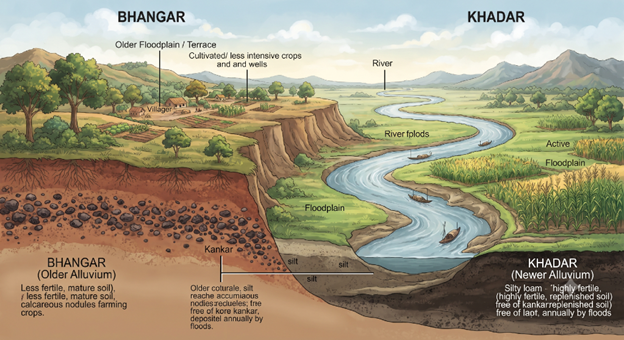
A. Bhangar (Older)
- Formation: Situated on higher terraces, lying well above the flood level (about 30 metres above the flood level).
- Composition: Composed of older alluvium, it features a more clayey and sticky composition, is generally dark colored, and is less fertile due to prolonged leaching and weathering.
- Kankar: A few metres below the terrace of the Bhangar lie beds of impure calcium carbonate (lime) nodules locally known as “Kankar”.
B. Khadar (Newer)
- Formation: Composed of newer alluvium, it forms the low-lying floodplains along riverbanks.
- Flooding: These areas are flooded almost every year, depositing a fresh layer of silt with each flood. This continuous renewal makes them the most fertile soils of the Gangetic system.
- Composition: They consist of sandy clays and loams; they are more dry and leached, less calcareous, and contain fewer carbonaceous elements (fewer kankars).
3. Geographical Area
- Major Basins: Extends widely across the Great Northern Plain, stretching from Punjab and Haryana through Uttar Pradesh and Bihar to West Bengal and Assam.
- Peninsular and Coastal Extensions: Found in the lower valleys of the Narmada and Tapti rivers, the eastern coastal deltas (Mahanadi, Godavari, Krishna, and Cauvery), and the northern Gujarat plains via a narrow corridor traversing Rajasthan.
4. Physical Characteristics
- Texture: Ranges widely from sandy loam to heavy clay. The soil texture tends to be more loamy and clayey in the lower Ganga plain and Brahmaputra valley, with the sand content progressively decreasing from west to east.
- Color: Varies from light grey to ash grey, heavily influenced by the depth of deposition, maturity of the soil, and parent material.
5. Major Crops Grown
Due to their high natural fertility, moisture-retention properties, and excellent response to irrigation, alluvial soils support intensive year-round cultivation of:
- Food Grains: Rice (paddy), wheat, maize, and barley.
- Cash Crops: Sugarcane, cotton, jute, and tobacco.
- Others: A wide variety of pulses and oilseeds.
Previous Year Questions Soil
Question 1
‘Gangani’ region of West Bengal has which type of soil? (WBCS PRE: 2020)
(A) Alluvial Soil
(B) Saline Soil
(C) Laterite Soil
(D) Terai Soil
Correct Answer: (C) Laterite Soil
Question 2
Plants receive nutrients from (Year: 2020)
(A) atmosphere
(B) chlorophyll
(C) soil
(D) light
Correct Answer: (C) soil
Question 3
What is the name of the Lake between Godavari and Krishna deltaic region? (WBCS PRE: 2020)
- (A) Kolleru Lake
(B) Pulicat Lake
(C) Chilika Lake
(D) Loktak Lake
Correct Answer: (A) Kolleru Lake
Question 4
Which region is called the granary of South India? (WBCS PRE: 2020)
(A) Madras
(B) Thanjavur
(C) Kanyakumari
(D) Coromondal coast
Correct Answer: (B) Thanjavur
Question 5
Radiocarbon dating technique is used to estimate the age of (WBCS PRE: 2020)
(A) rocks
(B) monuments
(C) soil
(D) fossils
Correct Answer: (D) fossils
পলিমাটি (Alluvial Soil)
পলিমাটি হলো ভারতের সর্বাধিক বিস্তৃত, ব্যাপক ও কৃষিকাজের দিক থেকে সবচেয়ে তাৎপর্যপূর্ণ মৃত্তিকা। প্রায় ১৫ লাখ বর্গকিলোমিটার এলাকা জুড়ে (দেশের মোট ভূখণ্ডের প্রায় ৪৩% থেকে ৪৫.৬%) বিস্তৃত এই মাটি ভারতের কৃষিভিত্তিক সমৃদ্ধির মূল ভিত্তি এবং দেশের এক বিরাট জনগোষ্ঠীর জীবিকা নির্বাহের প্রধান অবলম্বন।
১. গঠন ও উপাদান (Formation and Composition)
- উৎস: নদী, বায়ু, হিমবাহ এবং সমুদ্রতরঙ্গের মাধ্যমে পরিবাহিত পলি সঞ্চয়ের ফলে এটি মূলত গঠিত হয়েছে।
- পুষ্টি উপাদান: এই মাটিতে সাধারণত পটাশ, চুন এবং হিউমাসের প্রাচুর্য থাকে; তবে এতে সচরাচর নাইট্রোজেন ও ফসফরাসের ঘাটতি দেখা যায়।
২. শ্রেণিবিভাগ (Classification)
বয়স, অবস্থান এবং ভৌত বৈশিষ্ট্যের ওপর ভিত্তি করে পলিমাটিকে প্রধানত দুটি ভাগে ভাগ করা হয়:
- ভাঙ্গর (প্রাচীন পলিমাটি / Bhangar – Older)
- অবস্থান ও গঠন: নদী উপত্যকার উচ্চতর সোপানে অবস্থিত, যা প্লাবনভূমির স্বাভাবিক জলসীমার বেশ উপরে (বন্যা স্তর থেকে প্রায় ৩০ মিটার উঁচুতে) গড়ে ওঠে।
- গঠনপ্রকৃতি: প্রাচীন পলি দ্বারা গঠিত হওয়ায় এটি তুলনামূলকভাবে বেশি এঁটেল (clayey) ও আঠালো প্রকৃতির হয়। দীর্ঘমেয়াদি ক্ষয়ীভবন (leaching) ও আবহবিকারের কারণে এর রঙ সাধারণত কালচে এবং উর্বরতা তুলনামূলকভাবে কম।
- কাঁকর (Kankar): ভাঙ্গর মাটির স্তরের কয়েক মিটার নিচে অশুদ্ধ ক্যালশিয়াম কার্বনেটের (চুন) জমাটবদ্ধ নুড়ির স্তর দেখা যায়, যা স্থানীয়ভাবে “কাঁকর“ নামে পরিচিত।
- খাদার (নবীন পলিমাটি / Khadar – Newer)
- অবস্থান ও গঠন: নবীন পলি দ্বারা গঠিত এবং নদী তীরবর্তী নিচু প্লাবনভূমিতে এটি অবস্থান করে।
- প্লাবন ও পুনর্নবীকরণ: প্রতি বছর বন্যায় এই অঞ্চল প্লাবিত হয় এবং বন্যার জলের সাথে নতুন পলির স্তর জমা হয়। নিয়মিত এই পলিসঞ্চয়ের ফলে এটি গাঙ্গেয় সমভূমি অঞ্চলের সবচেয়ে উর্বর মৃত্তিকা।
- গঠনপ্রকৃতি: এটি প্রধানত বেলে–দোআঁশ ও দোআঁশ উপাদান দ্বারা গঠিত। এটি অপেক্ষাকৃত শুষ্ক, কম ক্ষয়িত, কম চুনযুক্ত এবং এতে কার্বনেট জাতীয় উপাদান বা কাঁকরের পরিমাণ খুবই কম থাকে।
৩. ভৌগোলিক বিস্তার (Geographical Area)
- প্রধান নদী অববাহিকা: ভারতের বিশাল উত্তর সমভূমি জুড়ে এটি সুদূরপ্রসারী—পাঞ্জাব ও হরিয়ানা থেকে শুরু করে উত্তর প্রদেশ, বিহার হয়ে পশ্চিমবঙ্গ ও আসাম পর্যন্ত বিস্তৃত।
- উপদ্বীপীয় ও উপকূলীয় বিস্তার: নর্মদা ও তাপ্তি নদীর নিম্ন উপত্যকা, পূর্ব উপকূলীয় বদ্বীপসমূহ (মহানদী, গোদাবরী, কৃষ্ণা ও কাবেরী) এবং রাজস্থানের মধ্য দিয়ে বিস্তৃত একটি সংকীর্ণ করিডোরের মাধ্যমে উত্তর গুজরাটের সমভূমি পর্যন্ত এটি ছড়িয়ে রয়েছে।
৪. ভৌত বৈশিষ্ট্য (Physical Characteristics)
- বুনট (Texture): বেলে–দোআঁশ থেকে শুরু করে ভারী এঁটেল মাটি পর্যন্ত এর বুনটে ব্যাপক ভিন্নতা দেখা যায়। নিম্ন গাঙ্গেয় সমভূমি এবং ব্রহ্মপুত্র উপত্যকায় এই মাটির বুনট তুলনামূলকভাবে বেশি দোআঁশ ও এঁটেল প্রকৃতির হয়; পশ্চিম থেকে পূর্ব দিকে অগ্রসর হলে পলিতে বালির অনুপাত ক্রমশ হ্রাস পায়।
- রঙ (Color): হালকা ধূসর থেকে ছাই রঙের হয়ে থাকে। পলি সঞ্চয়ের গভীরতা, মাটির পরিণত অবস্থা এবং উৎস শিলার ওপর ভিত্তি করে রঙের এই তারতম্য ঘটে।
৫. প্রধান উৎপাদিত ফসল (Major Crops Grown)
উচ্চ প্রাকৃতিক উর্বরতা, আর্দ্রতা ধারণ ক্ষমতা এবং সেচকাজের উপযোগী বৈশিষ্ট্যের কারণে পলিমাটিতে সারা বছর নিবিড় চাষাবাদ সম্ভব হয়:
- খাদ্যশস্য: ধান, গম, ভুট্টা এবং বার্লি (যব)।
- অর্থকরী ফসল: আখ, তুলা, পাট এবং তামাক।
- অন্যান্য ফসল: বিভিন্ন ধরনের ডালশস্য ও তৈলবীজ।
মৃত্তিকা বিষয়ক বিগত বছরের প্রশ্নাবলি (PYQs)
প্রশ্ন ১
পশ্চিমবঙ্গের ‘গনগনি’ (Gangani) অঞ্চলে কোন ধরনের মাটি দেখা যায়? (WBCS PRE ২০২০)
- (A) পলিমাটি
- (B) লবণাক্ত মাটি
- (C) ল্যাটেরাইট মাটি
- (D) তরাই অঞ্চলের মাটি
সঠিক উত্তর: (C) ল্যাটেরাইট মাটি
প্রশ্ন ২
উদ্ভিদ কোথা থেকে পুষ্টি উপাদান গ্রহণ করে? (WBCS PRE ২০২০)
- (A) বায়ুমণ্ডল
- (B) ক্লোরোফিল
- (C) মাটি
- (D) আলো
সঠিক উত্তর: (C) মাটি
প্রশ্ন ৩
গোদাবরী ও কৃষ্ণা নদীর বদ্বীপ অঞ্চলের মধ্যবর্তী হ্রদটির নাম কী? (WBCS PRE ২০২০)
- (A) কোলেরু হ্রদ (Kolleru Lake)
- (B) পুলিকট হ্রদ (Pulicat Lake)
- (C) চিলিকা হ্রদ (Chilika Lake)
- (D) লোকটাক হ্রদ (Loktak Lake)
সঠিক উত্তর: (A) কোলেরু হ্রদ
প্রশ্ন ৪
দক্ষিণ ভারতের শস্যভাণ্ডার (Granary of South India) নামে কোন অঞ্চল পরিচিত? (WBCS PRE ২০২০)
- (A) মাদ্রাজ
- (B) তাঞ্জাভুর
- (C) কন্যাকুমারী
- (D) করমণ্ডল উপকূল
সঠিক উত্তর: (B) তাঞ্জাভুর
প্রশ্ন ৫
রেডিওকার্বন ডেটিং পদ্ধতি (Radiocarbon Dating Technique) কোনটির বয়স নির্ধারণ করতে ব্যবহৃত হয়? (WBCS PRE ২০২০)
- (A) শিলা
- (B) স্মৃতিস্তম্ভ
- (C) মাটি
- (D) জীবাশ্ম
সঠিক উত্তর: (D) জীবাশ্ম